Matt Smith Realty
Marin County

Sausalito

Bridge Light, Bay Air, Bohemian Hills

Photo: Matthew Smith
The neighborhoods, mapped

Sausalito from above.

Bridgeway, the hillside above it, the houseboat docks at Waldo Point, and the GGNRA edge running into the Headlands. One town, four very different markets.

Neighborhoods of Sausalito
Local intelligence

What makes Sausalito different.

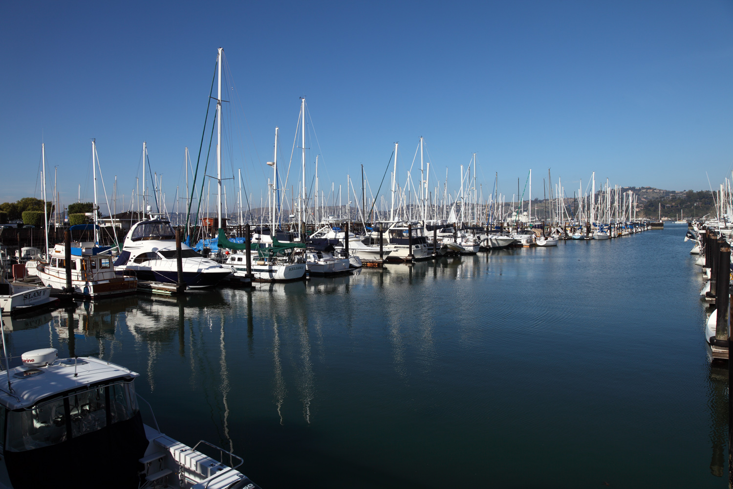
Sausalito is built on a hill that fell into the bay. The street grid is short and steep, the architecture is the most eclectic in Marin County, and the waterfront has been working since the 1880s. Bridgeway is the spine, lined with art galleries and the elephant statues of Plaza ViƱa del Mar, which traveled here from the 1915 Panama-Pacific International Exposition and anchor the park named for Sausalito's Chilean sister city. Caledonia is the village living room, and the hillside above New Town is where most of the inventory lives. Sun, fog, and view change block to block here, so the exact parcel matters as much as the neighborhood.

The houseboats are a category unto themselves. Waldo Point Harbor, Issaquah Dock, and Yellow Ferry Harbor each have their own personalities, slip rules, and assessment districts. Sales come with slip rights, dock association agreements, sewage hookup verification, and a live-aboard certification track that has nothing to do with traditional residential paperwork.

Fog rolls under the bridge most summer mornings. Then it burns off and you can see Alcatraz from your kitchen.

Sea-level rise is no longer abstract. The BCDC mapping shows Bridgeway, Caledonia, and the flats parcels in the inundation footprint under BCDC's 24-inch sea-level-rise scenario. FEMA AE already covers the waterfront. The city is engineering a Bridgeway resilience plan, and informed buyers ask about the elevation certificate before they ask about the kitchen.

For the hillside parcels, the conversation shifts. Slope stability, foundation engineering, and view easements dominate. The Sausalito News-style cottages built in the 1920s through 1940s often sit on cripple walls and ungraded slope, and they need a Level 1 seismic look before any offer goes hard. The reward is a daily commute to the ferry, a 30-minute crossing to the Embarcadero, and a view of the bridge that you do not forget.

The history here is unusually deep for a town this size. The northern flats were Marinship, the World War II shipyard that built 93 cargo ships and tankers between 1942 and 1945 and was the site of the landmark 1944 civil-rights case James v. Marinship. You can read that whole story across the bay at the Bay Model Visitor Center on Marinship Way, the Army Corps of Engineers' working hydraulic model of the entire San Francisco Bay and Delta, free to walk through. Just under the Golden Gate at historic Fort Baker sit Cavallo Point lodge and its Murray Circle restaurant, alongside the Bay Area Discovery Museum, the only children's museum in the country set inside a national park. This is a town that rewards the buyer who actually wants to live in their neighborhood.

Storefronts on Bridgeway in Sausalito
Storefronts on Bridgeway
Sausalito Yacht Harbor
Gabrielson Park waterfront
Gabrielson Park
Pockets of Sausalito

Neighborhoods of Sausalito.

Five named pockets, five different price tiers, each with its own sun and view. Houseboats trade on their own rules. Ranges below are working estimates; I confirm against current listings the day you search.

Hurricane Gulch south-facing hillside, Sausalito
Hurricane Gulch
$1.6M-$2.4M

South-facing hillside, view priority.

Banana Belt central Sausalito microclimate
Banana Belt
$1.8M-$2.7M

Microclimate sun, central.

Old Town Sausalito walkable Bridgeway
Old Town
$1.4M-$2.2M

Walkable Bridgeway, mixed condo and single-family.

Wolfback Ridge wooded crest above Sausalito
Wolfback Ridge
$2.0M-$3.1M

Wooded crest, privacy.

Waldo Point houseboats at the docks
Waldo Point
$800K-$1.4M

The houseboats themselves. Different rules apply.

Live + local

Mt Tam + the ferry, right now.

Two pieces of local intelligence buyers ask for first. The fire-cam feed off the East Peak lookout, and the Sausalito ferry schedule that anchors daily life.

Live from Mt Tam Fire Lookout
ALERTCalifornia camera network
Mt Tam East Peak
The AlertCalifornia camera network feeds a live wildfire watch view from the 2,571 ft summit. Live frames are blocked from embedding here for security, so open the full network in a new tab.
View live feed
Operated by UC San Diego, CAL FIRE, and partners. East Peak coverage spans Tam ridge, Cascade Canyon, and the Headlands above Sausalito.
Golden Gate Ferry
Sausalito to San Francisco, 30 minutes door to Embarcadero
Weekday peak
6:30am to 8:30pm, every 60 to 90 minutes
Weekday midday
Hourly to 90-minute intervals
Saturday
10:30am to 8:00pm, reduced service
Sunday + holidays
10:30am to 7:30pm, reduced service
Adult one-way ~$15 · Clipper card discount available
Confirm current fares at goldengate.org. Sausalito Ferry Terminal, Anchor Street + Humboldt Avenue. Live status: 511.org
Sample disclosure analysis

Every Sausalito listing has a paperwork story.

Our analyzer reads it before you do.

Photo: Frank Schulenburg, Wikimedia Commons, CC BY-SA 3.0
Disclosure realities

What we typically find in a Sausalito report.

Tap any item to expand. A representative sample disclosure analysis for the Sausalito market. Real reports are property-specific and run through the same engine used by our Marin and Sonoma client base.

Disclosure Package
Sausalito Listing
Sample TDS + NHD
Analyzed
Marine flood, FEMA AE +
Bridgeway, Caledonia, and the flats parcels sit inside FEMA Flood Zone AE. Federally backed mortgages require flood insurance on AE-zone properties, and premiums are climbing as Risk Rating 2.0 phases in. Pull the elevation certificate during disclosure review, confirm the base flood elevation, and price the policy before the offer goes hard. Open full report
Sea-level rise, BCDC projections +
BCDC mapping shows Bridgeway corridor, Caledonia, and the bayfront flats in the inundation zone under BCDC's 24-inch sea-level-rise scenario. Sausalito is engineering a Bridgeway resilience plan, but in the meantime, ground-floor occupancy on flats parcels carries climate risk that increasingly shows up in insurance binders. Hillside parcels above 30 feet elevation are not at direct flood risk.
Hillside slide history +
Steep west-side blocks above Bridgeway have slide events in the historical record, particularly after wet winters. NHD reports will flag Earthquake-Induced Landslide Zone overlays. Verify the geotechnical report, look for drainage history on the uphill neighbors, and confirm retaining walls have a permit history. Slope movement is the most expensive surprise on a Sausalito hillside parcel.
Foundation, 1920s-1940s cottages +
A meaningful share of Sausalito's housing stock is pre-1945, built on cripple walls and ungraded slope. Soft-story conditions, post-and-pier underpinning, and inadequate shear bracing are common. Budget a Level 1 seismic evaluation in contingency on any pre-war cottage. Retrofit costs run $25,000 to $80,000 depending on slope and access.
Houseboat-specific liability +
Houseboat sales are not standard real estate. Confirm slip rights, dock association rules, monthly assessment, sewage hookup status, live-aboard certification, and Coast Guard documentation. Waldo Point, Issaquah Dock, and Yellow Ferry Harbor each have their own governing structure. Title insurance and lender financing both work differently. A wrong assumption here costs months.
Elevation certificate on file +
Strong signal. An elevation certificate on file at the city, combined with documented permitted flood vents and a base floor above the BFE, can drop flood premiums materially and clears most carrier underwriting. On a long hold, that carrying-cost difference adds up.
View official CalFire FHSZ map for Sausalito
Analyze any Sausalito listing
Editorial moment

A Saturday in Sausalito.

Six chronological beats, the way a local actually moves through a weekend. Real addresses, real businesses, real timing.

07:50 AM
Espresso at Sausalito Bakery and Cafe
571 Bridgeway
Sit on the bay side. Watch the first ferry slide past Angel Island.
09:00 AM
Kayak launch from Sausalito Yacht Harbor
Sausalito Yacht Harbor, off Bridgeway
Paddle south along the houseboats. Glass water before the noon wind picks up.
11:30 AM
Tour the Bay Model Visitor Center
2100 Bridgeway, free admission
Working hydraulic model of the entire San Francisco Bay and Delta. Built by the Army Corps. Genuinely incredible.
01:00 PM
Lunch on the deck at Le Garage
85 Liberty Ship Way
Working garage turned French bistro. The waterfront tables fill fast. Get the moules.
03:00 PM
Houseboat tour at Waldo Point Harbor
Yellow Ferry Harbor area, Gate 6 Road
Walk Issaquah Dock. Every front porch is a different decade. Every roofline is a story.
05:30 PM
Golden hour at Battery Spencer
Conzelman Road, Marin Headlands
The iconic Golden Gate Bridge photo. Park up the road, walk down to the platform.
08:00 PM
Dinner at Scoma's Sausalito
588 Bridgeway
Bridgeway over the water. The crab Louis is the order. The light off the bay is the experience.
Top epic_score POIs

Ten places that define Sausalito.

Pulled from our 477-place leaderboard and ranked by epic_score. Real addresses, scroll the rail.

EPIC 95
VIEWPOINT
Battery Spencer
Conzelman Rd, Marin Headlands
The iconic Golden Gate Bridge view. Sunrise to last light.
94
STRIP
Bridgeway main strip
Bridgeway, downtown Sausalito
Water on one side, galleries and cafes on the other. The spine.
92
FERRY
Sausalito Ferry Terminal
Anchor St + Humboldt Ave
30-minute ride to the Embarcadero. The honest commute.
91
PARK
Plaza Vina del Mar
Bridgeway + El Portal
1915 Panama-Pacific elephants, civic heart, ferry-side plaza.
90
DOCK
Sausalito Houseboat docks
Waldo Point Harbor, Gate 6 Rd
Issaquah Dock, Yellow Ferry, Liberty Ship Way. A whole town floating.
89
MUSEUM
Bay Model Visitor Center
2100 Bridgeway, Sausalito
USACE working hydraulic model of the bay. Free admission.
88
PARK
Marin Headlands
948 Fort Barry, Sausalito
GGNRA gateway, Rodeo Beach, Point Bonita lighthouse trail.
87
FOOD
Bar Bocce
1250 Bridgeway, Sausalito
Wood-fired pizza, sand court, the bay-edge lunch.
86
FOOD
Le Garage
85 Liberty Ship Way
Working garage turned French bistro. Bayfront tables.
85
DRIVE
Conzelman Road
From US 101, Marin Headlands exit
The bridge approach photo. Hairpins, batteries, ocean drop-off.
A curated Saturday

A day in Sausalito.

Six chronological stops, the way locals actually move through a weekend. Bridgeway at dawn, headlands by mid-afternoon, oysters at sunset.

07:00 AM
Bridgeway walk

South to the ferry terminal at sunrise.

09:00 AM
Le Garage

Breakfast at 85 Liberty Ship Way.

11:00 AM
Bay Model Visitor Center

Working hydraulic bay at 2100 Bridgeway.

01:00 PM
Bar Bocce

Pizza on the sand at 1250 Bridgeway.

03:00 PM
Battery Spencer

Conzelman Road for the bridge view.

06:00 PM
Fish

Sunset oysters at 350 Harbor Drive.

Schools serving Sausalito

Where the kids go.

Sausalito Marin City School District serves K through 8. High schoolers attend Tamalpais High, which serves Sausalito as part of the Tamalpais Union HSD.

Sausalito Marin City School District
Grades K-8
K-8
Dr. Martin Luther King Jr. Academy
District unified campus, project-based, Marin City
~280students
Tamalpais Union HSD
Grades 9-12
9-12
Tamalpais High School
Serves Sausalito as part of Tamalpais Union HSD. The district's original campus, in Mill Valley.
~1,500students
Full school directory
Buyer questions

Sausalito FAQ.

What is the median home price in Sausalito in 2026?+
In Sausalito, pricing moves with each new listing and is best confirmed against current MLS data the day you search. Hillside homes with bay or bridge views trade above the median. Houseboats are a separate market entirely.
Is Sausalito at risk of sea-level rise?+
Yes. BCDC mapping shows Bridgeway, Caledonia, and the bayfront flats in the inundation zone under BCDC's 24-inch sea-level-rise scenario. The FEMA AE flood zone already covers waterfront parcels. Hillside parcels above 30 feet elevation are not at direct flood risk but should still be evaluated for slope and drainage.
How does the Sausalito ferry work?+
Golden Gate Ferry serves Sausalito, running to the SF Ferry Building roughly every 60 to 90 minutes weekdays. The crossing is about 30 minutes. Blue and Gold Fleet's Pier 41 service is currently suspended.
Which schools serve Sausalito?+
Sausalito Marin City School District serves K-8 with Dr. Martin Luther King Jr. Academy. For high school, Tamalpais High serves Sausalito as part of the Tamalpais Union HSD.
What are typical disclosure issues on Sausalito homes?+
Five patterns dominate. Marine flood exposure on Bridgeway and Caledonia parcels in FEMA AE. Hillside slide history on the steep west-side blocks. Foundation issues on older cottages. Sea-level rise projections that insurers increasingly price into binders. And for houseboat sales, a separate documentation track covering slip rights and live-aboard certification.
Should I buy in Sausalito or Tiburon?+
Sausalito is bohemian, walkable, and historic. Tiburon is sunnier, more formal, and oriented around Belvedere views. Sausalito sees more weekend tourist traffic on Bridgeway, but the hillside neighborhoods stay quiet. Tiburon offers a more residential feel. Houseboat life is a Sausalito phenomenon.
Who you are working with

Credentials, response time, accountability.

Your agent
Matt Smith
Luxe Places International Realty
Recognition
Gold Club 2025
Luxe Places International Realty
Licensed
DRE 02184215
California, in good standing
Response
24-hour reply
Every inquiry. Weekends included.
A Marin specialist on the record
Recognition
Gold Club
Luxe Places 2025
License
DRE 02184215
Brokered by Luxe Places International Realty
Matt Smith is a Marin-based realtor with a proprietary disclosure analysis system other agents don't have.
Responsible Broker Dennis Kevin Liebl, DRE 01211348. Full Spectrum Properties Inc DBA Luxe Places International Realty.
Ready to look at Sausalito on the ground? Schedule a Sausalito tour Analyze a listing